
July 18, 2024
How to Manage Survey Standards with CTC’s Survey Tools
A guide for civil engineers and surveyors who want to streamline their survey workflows with Civil 3D and other software
Surveying is a crucial part of any civil engineering project, but it can also be a time-consuming and error-prone process. That’s why many civil firms use CTC’s Survey Tools, part of the CIM Manager & CIM Project suites of add-ons for Civil 3D that help manage survey standards, and convert point file data. In this post, we will show you how to use CTC’s Survey Tools to improve your survey workflow with Civil 3D.
What are Survey Standards and Why are They Important?
Survey standards are the rules and conventions that define how survey data is collected, processed, and displayed in different software. With respect to Civil 3D Survey standards include things like survey codes, point formats, figure styles, and linework settings. Survey standards are important because they ensure that the survey data is consistent and compatible across different projects and software.
By using quality survey standards, you can save time and avoid errors when working with survey data. These survey standards should be applied across the entire organization to ensure an output that is consistent in quality and display for every project, because building a company brand for high quality output takes consistency.
How to Manage Survey Standards with CTC’s Survey Tools?
CTC’s CIM Manager Suite is a suite of add-ons for Civil 3D that help you manage survey standards and overall CAD Standards in a convenient and efficient way. The CIM Manager Suite include 4 main components that can help you with different aspects of survey standards management.
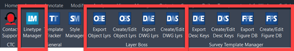
These are:
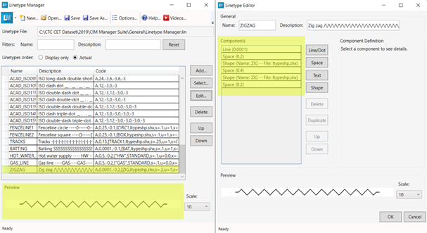
- Linetype Manager: This tool is a free tool in theis CIM suite that offers a much more dynamic way to create and edit .lin files then the conventional ways in AutoCAD. Providing a dynamic preview window to show changes as they are being made to a linetype.
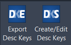
- Survey Template Manager: a tool that allows you to manage survey templates in Excel, instead of using the clunky interfaces of Civil 3D. You can create and edit description keys, figure prefix databases, and linework code sets in a familiar spreadsheet environment, and then import them into Civil 3D with a few clicks.
- Layer Boss: Speeds up Civil 3D layer management and creation by syncing with an Excel spreadsheet. All layer properties can be managed from an external spreadsheet, allowing faster template management. All Civil 3D object layer settings can be synced in the same way. Initial spreadsheet creation occurs through a simple export option from any drawing or template file.
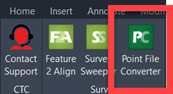
- Point File Converter: Although this tool is in the CIM Project Suite, this is a tool that allows you to convert point files between different formats, such as CSV, FBK, LandXML, and more. You can also manage multiple survey coding standards and translate them to different software, such as MicroStation, Trimble, and others.
To demonstrate how to use CTC’s Survey Tools, we will follow the typical survey workflow and show you how each tool can help you with each step. We will use Civil 3D and TBC as examples of software, but you can use other software as well, depending on your needs and preferences.
Configure Survey Codes
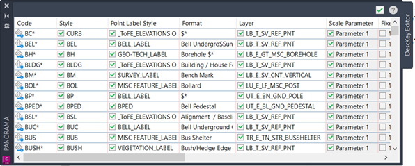
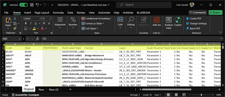
The first step of any survey workflow setup is to configure the survey codes that will be used to define the survey information. Survey codes are essential for creating accurate and consistent survey data, as they control how the points and survey figures are named, described, and displayed in the software. Civil 3D uses three means of managing survey codes: description keys, figure prefix databases, and linework code sets. These can be created and edited in Civil 3D, but the interfaces are not very user-friendly and can be very time-consuming. That’s why CTC’s Survey Template Manager is a better option, as it allows you to export and manage survey codes in Excel, which is a more familiar and flexible environment. To use Template Manager, you need to follow these steps:
- Open the Survey Template Manager tool from the CTC Survey ribbon in Civil 3D.
- Select the type of survey code you want to create or edit: description keys or figure prefix databases.
- Click on the Excel icon to open the survey template in Excel.
- Fill in the survey template with the survey standards information you want to use.
- Save and close the Excel file.
- Click on the Import icon in the CIM Managers Suite ribbon in Civil 3D to import the survey template from excel.
- Verify that the survey codes are imported correctly in Civil 3D and click Apply.
By using the Survey Template Manager tools, you can save time and avoid errors when creating and editing survey codes. You can also easily document these standards for use in formal onboarding documentation and CAD Standards.
Perform the Survey
The next step of the survey workflow is obviously to perform the survey in the field. The survey data is stored in the data collector, and can be exported to different formats, such as CSV, FBK, LandXML, and more. Most of which can be handled by Civil 3D.
Import Survey Content to Civil 3D
The next step of the survey workflow is to verify and import the survey content, which means checking that the survey points and figures are correct and consistent with the survey standards followed by importing into Civil 3D.
Checking the survey data files is a crucial step in the process that will help confirm the point code and line work standards that have been used, as well as identify initial errors in the field data. Taking time for this step can pay dividends in later processing steps with data in Civil 3D. This step is generally easiest when working with a .CSV file in ASCII format. (ASCII format is the widely used format for point files these days, offering a typical five pieces of information. Point number, northing, easting, elevation, description or PNEZD)
During import, Civil 3D uses a survey database to store and manage survey data, which can be imported from different formats, such as CSV, FBK, and more. During this import process line work is automatically created based off the figure prefix database file and the linework code sets, and survey points are stylized by the description key set.
Once this survey data is imported into Civil 3D it can then be assessed again to ensure that it represents the existing conditions in the field. Looking for 0 elevations, and other oddities that can occur from incorrect inputs into the data collector or improper rod heights while surveying.
Now the data is imported into Civil 3D, the rest of the design can continue with surfaces, corridors, pipe networks, and other design aspects.
Compatibility Issues with Survey Standards & Data Files
Often times organisations subcontract surveys. This can be an issue if these subcontractors don’t adhere to the survey standards the organization sets out. If the subcontracted surveyor does not adhere to the CAD standards of the organization, survey files cannot be read correctly. This leads to incorrect line work, poor stylization, and misinterpreted data.
Point File Converter is a tool in the CTC CIM Project Suite That can help manage incompatibilities between survey standards and data files. It works best with .CSV files, and uses a spreadsheet “translation file” that spells out code conversions. The tool will read the conversion and apply them to one or more point files. Line work codes, as well as prefixes and suffixes in the coding are all accounted for.
This offers unparalleled flexibility when working with subcontracted surveyors and their are various survey standards. This should also improve the surveyor’s efficiency as they are not forced to work in a foreign survey code list.
Conclusion
CTC’s Survey Template Manager Tools are part of a CIM Manager suite of add-ons for Civil 3D that help you manage survey standards, and convert point files. By using CTC’s Survey Manager Tools, you can streamline your survey workflow with Civil 3D and improve the quality and efficiency of your survey data and civil projects. To learn more about CTC’s Survey Tools, visit our website or contact us for a demo.
Related Posts

-
Maximizing Security and Collaboration with Autodesk Construction Cloud: A SolidCAD Perspective
At SolidCAD, we’re proud to partner with Autodesk to bring forward-thinking solutions and services to the construction technology landscape. Autodesk’s recent strides in trust, security, and collaboration ...
-
Revolutionizing Contract Administration with Digital Transformation
In the ever-evolving AECO (Architecture, Engineering, Construction, and Operations) landscape, effective contract administration is paramount. At SolidCAD, we recognize that while many of our clients use multiple ...

- Accruent
- Advanced Manufacturing
- Architecture
- Architecture
- Architecture - Blog
- Assembly Line Automation
- AutoCAD
- Autodesk
- Autodesk Construction Cloud
- Automotive
- BIM
- Blog
- Blog Posts
- Building Design & Engineering Services
- Building Engineering
- Building Engineering - Blog
- Building Product & Fabrication
- CAD
- CAM, CNC & Machining
- Civil 3D
- Civil Infrastructure
- Civil Infrastructure & GIS Services
- Civil, Survey & GIS
- CNC Machining Services
- Construction
- Construction
- Construction Project Lifecycle
- Consulting Services
- Consumer Products
- CPQ & Aftermarket
- CTC Software
- Data Management
- Digital Transformation
- Energy & Utilities
- Engineering
- Engineering
- General
- Government & Public Sector
- Industrial Machinery
- Industries
- Industry
- Industry Topics
- Infrastructure
- Inventor
- KnowledgeSmart
- Manufacturing
- Mining
- News
- Pinnacle Series
- PLM
- PLM & PDM
- Product Lifecycle Management
- Revit
- Sales and Aftermarket for Manufacturers
- Simulation & Analysis
- Software & Technology
- Software Development
- Thought Leadership
- Tips & Tricks
- Visualization
- Visualization & Reality Capture Services